Whoever you are, whatever you seek, it all starts here.

When
Who
 

Taste of the Rift Valley: The Essential Lake Naivasha Cultural Food Experience

Experience the vibrant heart of Kenya at Lake Naivasha, where the flavors of freshly grilled fish, Ugali, and Kachumbari come alive against a stunning lakeside backdrop. Nestled in the Great Rift Valley, this unique culinary adventure invites you to dine by the water’s edge, watch hippos at sunset, and connect with the warmth of the local community. Whether you’re a foodie, a nature lover, or a cultural explorer, Lake Naivasha offers an unforgettable taste of authentic Kenyan hospitality and tradition

The Authentic Flavour of Kenya: Lakeside Dining at Lake Naivasha

For many travelers, Kenya is defined by the sweeping savannas of the Masai Mara. Yet, the country’s cultural heartbeat is just as alive along the Great Rift Valley lakes.

Lake Naivasha, a freshwater jewel surrounded by acacia forests and volcanic landscapes, offers more than scenery—it’s a place where food, people, and nature come together. Here, you can savor the joy of an open-air, lakeside feast featuring the quintessential Kenyan trio: freshly grilled fish, Ugali, and Kachumbari.

 The Culinary Trio: Fish, Ugali, and Kachumbari

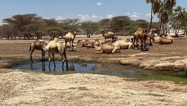
  • Fresh Fish from the Lake – Tilapia, common carp, or Nile perch, caught that morning and grilled over a charcoal jiko. Seasoned simply with salt, pepper, and local herbs, it’s a celebration of freshness.
  • Ugali – The national staple, a dense cornmeal porridge eaten by hand. It’s the perfect partner to smoky fish and tangy relish.
  • Kachumbari – A raw salad of tomatoes, onions, coriander, and lemon juice. Its zesty freshness balances the richness of the meal.

This trio is more than food—it’s a cultural ritual of sharing, simplicity, and community.

 A Majestic Backdrop: Wildlife and Scenery

Dining by Lake Naivasha is a feast for the senses:

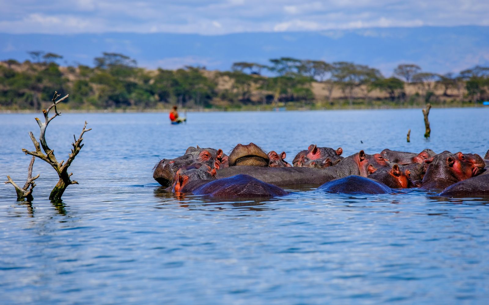
  • Hippos in the shallows – Emerging at dusk to graze, they provide a humbling reminder of nature’s power.
  • Birdwatcher’s paradise – Over 400 species, from African Fish Eagles to kingfishers, fill the skies and papyrus fringes.
  • Local hospitality – The warmth of the Naivasha community is the final ingredient, turning a meal into a cultural exchange.

How to Access Lake Naivasha Shore

Unlike many Kenyan lakes, Lake Naivasha has public access points where visitors can reach the shoreline for cultural food experiences, boat rides, or simply to enjoy the view.

Access Point

Description

Coordinates

Karagita Public Beach

Main public entry, popular with locals, boat rides, and fish stalls.

-0.7485, 36.3902

Kamere Beach

Rustic access point with local fishermen and fresh fish vendors.

-0.7541, 36.3798

Crescent Island Gate

Entry to the lagoon and wildlife sanctuary, ideal for combining food and nature walks.

-0.7652, 36.3935

South Lake Road Junction

Main tourism corridor with lodges, cultural food setups, and lake views.

-0.7702, 36.3731

 Public Access Roads

  • South Lake Road – The primary tourism road, lined with lodges and cultural food spots.
  • Moi South Lake Road – Connects Naivasha town to Karagita and Kamere beaches.
  • Naivasha–Moi North Lake Road – Leads to Crescent Island and northern access points.

These roads are accessible from the Nairobi–Naivasha Highway (A104), making it easy for day trips or weekend getaways.

How to Book Your Naivasha Food Adventure

  • Stay at a Lakeshore Lodge – Many lodges along South Lake Road offer curated “Aqua Gastronomy” experiences.
  • Book a Local Boat Safari – Request a traditional lakeside lunch or dinner as part of your package.
  • Visit During Dry Season (June–October) – Best weather for open-air dining and wildlife viewing.

Final Bite: Culture, Cuisine, and Connection

Lake Naivasha is more than a stopover—it’s a cultural immersion. From the smoky aroma of grilled fish to the laughter of local chefs and the sight of hippos grazing at sunset, every detail connects you to Kenya’s heart.

Don’t just see the Rift Valley—taste it, feel it, and live it on the shores of Lake Naivasha.


Chalbi Desert

Chalbi Desert

Unveiling the Jade Sea Gateway: Your Ultimate Guide to the Chalbi Desert Expedition

The Chalbi Desert, a vast, shimmering expanse in Northern Kenya, is the only true desert in the country and a critical stop on any expedition to the remote Lake Turkana (the "Jade Sea"). Its name, meaning "bare and salty" in the local Gabbra language, perfectly captures its otherworldly beauty and its profound challenges.

For the intrepid traveler, crossing the Chalbi is a rewarding journey into the heart of Kenya's rugged northern frontier, offering unique cultural encounters and starkly beautiful landscapes.


Key Facts & What You Will See

Feature

Details

Size & Location

The Chalbi Desert covers approximately 100,000 square kilometers (or about $38,600$ sq mi) in Marsabit County, stretching towards the Ethiopian border. It lies east of Lake Turkana.

Origin

It is an ancient, dried-up lake bed, a geological wonder composed of coarse sand, pure rocks, immense clay, and salt pans.

What to See

Shimmering Salt Flats: Vast, flat, cracked earth that creates breathtaking optical illusions and mirages, especially when dry. Volcanic Hills: The desert is surrounded by ancient volcanic craters and lava flows, creating a dramatic, contrasting panorama. Kalacha Oasis: A surprising, palm-fringed oasis on the edge of the desert, serving as a vital water source and a center for the local Gabbra community. Stark Beauty: The intense heat, red soil, and endless, dramatic horizons are a photographer's dream.

The Journey to Turkana

The Chalbi Desert is the final, challenging stretch before reaching the eastern shores of Lake Turkana, notably the town of Loiyangalani, home to the annual cultural festival and gateway to Sibiloi National Park.


Wildlife and Communities: Life in the Extreme

Despite the harsh environment, life has found a way to thrive in and around the Chalbi Desert.

Desert Wildlife: The Adapted Few

Wildlife sightings are less about mass herds and more about spotting highly adapted species surviving in one of the hottest climates in Kenya. Keep an eye out for:

  • Grevy's Zebra: The largest and most threatened of the zebra species, endemic to Northern Kenya.
  • Beisa Oryx: A large antelope with long, straight horns, perfectly adapted to the arid climate.
  • Somali Ostrich: Distinguished by its blue neck and legs.
  • Reticulated Giraffe: A visually stunning subspecies, often spotted near the edges of the desert.

The Resilient Communities

The desert is home to several nomadic pastoralist tribes whose ancient knowledge is key to navigating this landscape.

  • Gabbra: A semi-nomadic community whose language gives the desert its name. They are predominantly found in the eastern part, relying on camels for transport and survival.
  • Rendille: Primarily live on the southern edges of the desert, also known for their camel herding traditions.
  • Turkana & El Molo: Found further west, particularly around the shores of Lake Turkana. A cultural tour offers invaluable insight into their survival strategies, beadwork, and unique ways of life.

Challenges and Dangers of the Chalbi Crossing

The Chalbi Desert is a true wilderness destination that demands respect, meticulous planning, and an experienced guide.

1. Extreme Climate and Dehydration

  • Danger: Daytime temperatures frequently soar past $40 celsius ($104F) with intense sun and high winds. Dehydration and sunstroke are major risks.
  • Mitigation: Carry vastly more water than you think you need. Wear loose, light-colored clothing, a wide-brimmed hat, and strong sunscreen.

2. Vehicle Breakdowns and Getting Stuck

  • Danger: The terrain is unpredictable, shifting from hard-cracked earth to soft sand dunes and sudden rocky lava flows. Vehicle breakdowns are common due to the rugged conditions, and getting stuck in soft sand is a high probability.
  • Mitigation: Only travel in a well-maintained 4x4 safari vehicle (usually a Land Cruiser). Ensure you have spare tires, recovery gear (shovels, sand ladders, tow ropes), and a knowledgeable driver/guide experienced with desert driving.

3. Navigational Hazards

  • Danger: There are virtually no road signs or permanent landmarks across the main salt pan. Tracks can shift or disappear entirely after wind or rain.
  • Mitigation: Never attempt to cross without a professional local guide who knows the current tracks and weather conditions. GPS and satellite communication devices are essential.

4. Flash Flooding (Seasonal)

  • Danger: Although a desert, the flat, baked-clay pan cannot absorb water quickly. During and immediately after the short and long rainy seasons (April-June and November-December), the desert can flood, becoming an impassable expanse of sticky, deep mud that can trap vehicles for days.
  • Mitigation: Check seasonal weather conditions rigorously. Tours usually avoid the crossing entirely during the peak rainy months. If the track is wet, use an alternative, longer transit route.

Safety and Practical Tips for Your Expedition

  • Go Guided: This is the most critical safety advice. Book your trip through a reputable safari operator who provides a robust, fully-equipped 4x4 vehicle, an experienced driver, and reliable communication gear.
  • Communication: Have a satellite phone or high-frequency radio, as mobile phone reception is non-existent for long stretches.
  • Emergency Plan: Ensure your operator has a clear emergency protocol and a support network in the nearest towns (Marsabit, Loiyangalani, or North Horr).

What to Do If Stuck or Car Breaks Down:

  • Stay with the Vehicle: Your vehicle is the most visible object for rescue and provides essential shade from the sun. Do not wander off.
  • Signal for Help: Use your satellite communication device immediately.
  • Conserve Resources: Ration water and food strictly. Minimize activity to reduce heat and dehydration.
  • Get Shade: Erect a tarpaulin or use the vehicle doors to create additional shade. Your experienced guide will know the best immediate actions to take.

Connecting to Lake Turkana

The Chalbi Desert is a spectacular but demanding prelude to the "Jade Sea." The primary destinations connecting the two are:

  • Loiyangalani: A small town on the southeastern shore of Lake Turkana, serving as the cultural and tourism hub for the eastern side.
  • Sibiloi National Park: Located further north, famed as the "Cradle of Humankind" for its hominid fossil sites (Koobi Fora).

A journey through the Chalbi Desert is a unique, unforgettable experience that tests the limits of both man and machine, offering an intimate look at a truly raw and majestic corner of the world.


Lake Turkana

Lake Turkana

Lake Turkana Travel Guide: Remote Rift Desert Shorelines

Quick facts box

  • Coordinates: 3.4130° N, 36.0825° E
  • Region: Turkana County
  • Nearest town: Lodwar
  • Size: approx. 6,405 km²
  • Ecotype: saline; arid/semi-desert lake
  • Best months to visit: Jan–Feb (dry, clearer access); Jun–Sep (cooler)
  • Entry requirements: County permits recommended; arrange via tour operator
  • Typical transport: charter flights to Lodwar; 4x4 road expeditions

Snapshot overview

Lake Turkana is a vast, otherworldly saline lake in Kenya’s far north, framed by semi-desert landscapes and rich paleoanthropological history; it rewards travellers seeking dramatic scenery, large waterbird congregations, and cultural encounters with Turkana and neighboring pastoral communities. Safety note: travel in northern Kenya requires planning, local guides, and up-to-date security advice.

Lake Turkana UNESCO Heritage and Human History

Lake Turkana National Parks — made up of Sibiloi National Park, Central Island and South Island National Parks — is a UNESCO World Heritage serial property recognised for exceptional natural values: major breeding grounds for waterfowl and Nile crocodiles and globally significant fossil deposits at Koobi Fora that have informed understanding of paleo-environments and faunal evolution UNESCO World Heritage Centre.

The Koobi Fora and wider Turkana Basin fossil sites have produced a dense sequence of vertebrate and hominin remains spanning millions of years, including landmark discoveries that pushed back the timeline of early bipedal ancestors and produced nearly complete hominin specimens such as the famous "Turkana Boy" — evidence that makes the basin one of the world’s principal laboratories for human origins research National Geographic Education Kenyasafari.com.

Human presence around the lake extends across millennia, with archaeological and palaeoenvironmental records showing changing shorelines, shifting ecosystems and long-established pastoralist and fishing lifeways; these records link environmental change to human adaptation, trade and migration across the Horn of Africa region National Geographic Education Kenyasafari.com.

UNESCO listing shapes site management and visitor access: protected zones and permit regimes around Central Island and Sibiloi support both ongoing scientific research and regulated tourism, while conservation measures aim to safeguard fossil localities, breeding habitats and community livelihoods against contemporary threats such as shoreline change and resource pressure UNESCO World Heritage Centre Kenyasafari.com.


How to get there

From Nairobi (Jomo Kenyatta or Wilson Airport): Fly to Lodwar (charter or scheduled regional flight, ~1.5–2 hours); from Lodwar fly or drive to lakeshore sites. By road from Nairobi: expect 12–18 hours with a high-clearance 4x4 and experienced driver, poor surfaces beyond Kitale/Moyale routes; not recommended for standard cars.

GPS-ready coordinates for main access point (Central Turkana shore, approximate): 3.4130, 36.0825. Google Maps one-line direction: "Lodwar, Kenya to Lake Turkana 3.4130,36.0825".

Public transport: limited matatu or long-distance bus services to Lodwar; onward lakeshore travel requires private 4x4 or guided vehicle. Driving times: Lodwar to key beaches/peninsulas 1–4 hours depending on destination and road condition. 4x4 is strongly recommended.

Detailed travel guide sections

Getting around near the lake

  • Local travel is by 4x4, walking between camps, and small boats at seasonal inlets. Fuel and spares are limited; carry water, extra fuel jerrycans, and satellite phone where possible. Parking at lodges and community camps is basic but available.

Where to stay

  • Lodwar offers guesthouses and small lodges; remote lakeshore camps are community-run or expedition-style tented camps.
  • Recommended-property template for editors: "Name; Type: community camp; Sleeps: 8; Facilities: solar power, camping platforms, local guide included; Price range: moderate; Booking: local lodge or operator."

What to do (top 8)

  1. Flamingo and waterbird watching — early morning; 2–3 hours.
  2. Boat excursion to seasonal bays — half to full day.
  3. Cultural visit to Turkana homesteads and markets — half day.
  4. Explore Central Island National Park (volcanic landscape, nesting birds) — half to full day.
  5. Sunset photography on the northern shoreline — 1–2 hours.
  6. Visit paleoanthropological sites and local museums — 2–4 hours.
  7. Guided fishing trips with local fishers — half day.
  8. Overland 4x4 expedition across desert corridors — multi-day.

Animals and birdwatching

  • Expect large congregations of flamingos in sheltered bays and seasonal inlets, Nile crocodiles in shallower edges, and waterbirds such as pelicans and terns. Best sightings at dawn and dusk. Ethical viewing: keep distance, avoid disturbing nesting colonies, and use guides who respect breeding seasons.

Community and social impact

  • Main communities include Turkana pastoralists and fisher groups; tourism income is sporadic but valuable when channeled through local enterprises. Recommended community experiences: guided cultural walks, homestays, and purchasing craft directly from artisans. Prefer operators that pay fair wages and contribute to communal projects.

Economic profile

  • Livelihoods combine pastoralism, small-scale fishing, and cross-border trade. Tourism provides seasonal supplemental income through guiding, lodging, and crafts; income levels fluctuate with water and fish stocks and access conditions.

History and culture

  • Lake Turkana basin is rich in paleoanthropological finds and has long-standing pastoralist cultural systems. Respect cultural norms around photography and request permission before entering homesteads or taking portraits.

Climate change impact

  • Observed reports indicate receding shorelines in some areas, altered seasonal fish availability, and increased water temperature variability. Visitors can reduce footprint by minimizing single-use plastic, supporting adaptive community projects, and choosing low-impact tour operators.

Practical guidance for tourists

Packing list

  • Sturdy 4x4 shoes, sun hat, strong sunscreen, lightweight long-sleeve clothing, personal water purification tablets, high-SPF lip protection, binoculars, headlamp, spare fuel and basic toolkit.

Health and safety

  • Carry basic first-aid and anti-diarrheal medication; ensure up-to-date vaccinations per travel clinic advice; avoid swimming in unknown shallows (crocodile risk). Bring mosquito protection for dusk periods.

Accessibility

  • Terrain is rugged; many sites are not wheelchair-accessible. Contact operators in advance for assistance planning.

Responsible tourism checklist

  • Hire local guides; buy local produce and crafts; respect wildlife distances; follow waste management guidance; donate to vetted community conservation projects.

FAQ section

  1. Is Lake Turkana safe to visit? Arrange travel with reputable local operators, monitor security advisories, and use guides for remote areas.
  2. When is the best time to see flamingos? Flamingos congregate seasonally in sheltered bays; cooler dry months (Jan–Feb and Jun–Sep) often offer reliable sightings.
  3. Can I swim in Lake Turkana? Swimming is not recommended due to crocodiles and saline/variable water quality.
  4. Do I need permits to visit Central Island? Central Island is a protected area; check with county authorities or operators for permits.
  5. How do I pay for services? Cash (Kenyan shillings) is preferred in Lodwar and lakeshore communities; ATMs are limited.
  6. Are guided tours necessary? Yes — guides provide cultural context, safety, and local logistics expertise.
  7. What wildlife can I expect? Flamingos, pelicans, Nile crocodiles, and several waterbird species; terrestrial mammals are rarer near the shorelines.
  8. Is mobile coverage available? Coverage is patchy; expect limited service outside Lodwar.
  9. Can I combine Lake Turkana with other northern parks? Yes — itineraries often link with Sibiloi National Park and regional cultural visits.
  10. How to support local communities responsibly? Book locally-run services, pay fair prices, and prioritize community-owned camps and guides.

Sample tour plan

Lake Turkana is a remote and challenging destination, often requiring a multi-day journey by road or a fly-in safari. The itineraries below are based on common tour packages and highlights the main attractions.


Sample 3-Day Lake Turkana Itinerary (Fly-in Safari)

This itinerary focuses on the western shore (Lodwar area) and the main island park, offering a balance of nature, culture, and relaxation.

Day

Morning

Afternoon

Evening

Overnight

Day 1: Arrival & Lakeside

Fly from Nairobi (Wilson Airport) to Lodwar Airport. Meet your guide and transfer to your lakeside accommodation (e.g., Eliye Springs or a nearby camp).

Check-in, have lunch. Relax by the lake or a natural spring (like Eliye Springs). Optional short walk around the resort area.

Enjoy a sundowner over the "Jade Sea" (Lake Turkana) watching the color changes. Dinner and cultural discussion or storytelling.

Eliye Springs / Lakeside Camp

Day 2: Central Island National Park

Early breakfast. Take a thrilling boat excursion to Central Island National Park (Crocodile Island).

Hike around the island's volcanic craters: Crocodile Lake (major Nile crocodile breeding ground), Flamingo Crater Lake, and Tilapia Lake. Picnic lunch on the island.

Return boat ride to the mainland. Time for a refreshing swim or rest at the camp.

Dinner and overnight at Eliye Springs / Lakeside Camp

Day 3: Culture & Departure

Check out and drive back to Lodwar Town. Visit the Turkana Cultural Museum to learn about the region's history, the Turkana people, and the famous paleoanthropological discoveries.

Explore Lodwar town, including local markets or a nearby traditional Turkana village for a cultural interaction. Lunch in Lodwar.

Transfer to Lodwar Airport for your return flight to Nairobi.

Depart


Sample 5-Day Expedition (Road/Overland)

This option is for the adventurous traveler, incorporating the eastern shore and the paleontological sites, often combined with a drive through the challenging northern Kenyan terrain (e.g., via Marsabit or Samburu).

Day

Route/Focus

Highlights & Activities

Overnight

Day 1

Nairobi to Samburu/Marsabit

Begin the long overland journey. Drive through central Kenya into the arid northern region. Game drive (if passing through Samburu).

Samburu Area / Marsabit (Camp or Lodge)

Day 2

Across the Desert to Loiyangalani

Continue the journey, traversing dramatic desert landscapes like the Chalbi Desert (seasonal/optional). Arrive at Loiyangalani on the eastern shore of Lake Turkana.

Loiyangalani (Camp or Lodge)

Day 3

Eastern Shore & El Molo Tribe

Cultural visit to the village of the El Molo, Kenya's smallest and most unique tribe. Visit the Desert Museum in Loiyangalani. Boat trip on the lake for photography and sunset.

Loiyangalani (Camp or Lodge)

Day 4

Sibiloi National Park & Cradle of Humankind

Drive north to Sibiloi National Park (UNESCO World Heritage Site). Explore the Koobi Fora fossil sites, where hominid fossils like the "Turkana Boy" were discovered. Visit the Koobi Fora Museum.

Sibiloi National Park (Camp)

Day 5

Departure or Southward Journey

Begin the long drive south from Sibiloi/Loiyangalani, or take a chartered flight (if pre-arranged) to a major hub for onward travel.

En Route / Depart

Note: Road trips to Lake Turkana are extremely demanding, requiring sturdy 4x4 vehicles, experienced drivers/guides, and preparation for harsh, hot, and remote conditions. Many tours prefer the fly-in option for the western shore to save time and avoid the most difficult terrain.


Lakes in Kenya: Complete Guide to Rift Valley, Freshwater & Crater Lakes

Kenya is a land of breathtaking landscapes, rich biodiversity, and vibrant culture. While it is often celebrated for its iconic wildlife safaris and savannahs, one of the country’s most remarkable features is its diverse collection of lakes. From the mighty Lake Victoria—Africa’s largest freshwater lake—to the shimmering Lake Turkana in the arid north, Kenya’s lakes tell stories of geology, ecology, economy, and culture.

This comprehensive guide explores all major lakes in Kenya, their sizes, locations, classifications, and their ecological, economic, and cultural significance. Whether you are a traveler, researcher, or nature enthusiast, this article will serve as your ultimate resource.


📍 Overview of Lakes in Kenya

Kenya has over 20 major lakes, classified into:

  • Freshwater Lakes (e.g., Victoria, Naivasha, Baringo, Ol Bolossat)
  • Saline/Alkaline Lakes (e.g., Turkana, Nakuru, Bogoria, Magadi)
  • Crater and Alpine Lakes (e.g., Paradise, Simbi Nyaima, Michaelson)
  • Seasonal/Ephemeral Lakes (e.g., Amboseli, Kamnarok, Logipi)

Most of these lakes lie along the Great Rift Valley, a massive geological fault line running through Kenya, which explains their varied chemistry and unique ecosystems.


📊 Table of Major Lakes in Kenya

Lake Name

Size (km²)

Location

Classification

Key Features

Lake Victoria

68,800 (Kenya ~4,100)

Western Kenya (shared with Uganda & Tanzania)

Freshwater

Largest in Africa, fishing hub

Lake Naivasha

~139

Rift Valley, Nakuru County

Freshwater

Hippos, 400+ bird species

Lake Baringo

~130

Rift Valley, Baringo County

Freshwater

Crocodiles, hippos, birdlife

Lake Jipe

~30

Border of Kenya & Tanzania

Freshwater

Near Tsavo West NP

Lake Chala

~4.2

Border of Kenya & Tanzania

Freshwater (crater lake)

Scenic volcanic crater

Lake Ellis

<1

Eastern slopes of Mt. Kenya

Freshwater (alpine)

High-altitude trekking

Lake Michaelson

<1

Mt. Kenya

Freshwater (alpine)

Glacier-fed alpine lake

Lake Ol Bolossat

~43

Nyandarua County

Freshwater

Bird sanctuary

Lake Turkana

~6,405

Northern Kenya

Saline/alkaline

Largest desert lake

Lake Nakuru

~45

Rift Valley, Nakuru County

Saline/alkaline

Flamingos, rhinos

Lake Elmenteita

~20

Rift Valley, Gilgil

Saline/alkaline

UNESCO World Heritage Site

Lake Bogoria

~34

Rift Valley, Baringo County

Saline/alkaline

Hot springs, flamingos

Lake Magadi

~104

Kajiado County, Rift Valley

Saline/alkaline

Soda ash mining, flamingos

Lake Logipi

~6

Suguta Valley, Rift Valley

Saline/seasonal

Flamingos, seasonal flooding

Lake Natron

~1,040 (Kenya shares small part)

Border with Tanzania

Saline/alkaline

Flamingos breeding ground

Lake Paradise

~1

Marsabit National Park

Crater lake

Scenic forest lake

Lake Simbi Nyaima

~0.5

Homa Bay County, Nyanza

Crater lake

Linked to Luo folklore

Lake Kamnarok

~1 (variable)

Kerio Valley, Elgeyo Marakwet

Seasonal lake

Crocodile refuge

Lake Amboseli

~200 (seasonal)

Amboseli National Park

Seasonal lake

Floods in rainy season

Lake Alablad

Variable

Near Lake Magadi, Rift Valley

Seasonal lake

Rare ephemeral lake


🏞️ Freshwater Lakes of Kenya

Freshwater lakes are vital for human consumption, irrigation, and fishing. They are also biodiversity hotspots.

  • Lake Victoria – Supports millions of people with fishing (notably Nile Perch and Tilapia), transport, and agriculture.
  • Lake Naivasha – A hub for Kenya’s flower farming industry, supplying Europe with cut flowers.
  • Lake Baringo – Home to unique fish species and a cultural center for the Njemps people.
  • Ol Bolossat – The only lake in Nyandarua, a crucial water source for livestock and birdlife.

🌋 Saline & Alkaline Lakes

These lakes are highly mineralized due to Rift Valley geology. They are unsuitable for drinking but vital for flamingos and other wildlife.

  • Lake Turkana – Known as the Jade Sea, it supports crocodiles, fish, and local pastoralist communities.
  • Lake Nakuru & Elmenteita – Flamingo sanctuaries and part of a UNESCO World Heritage Site.
  • Lake Bogoria – Famous for geysers, hot springs, and massive flamingo populations.
  • Lake Magadi – Source of soda ash, a key economic mineral for Kenya.

🏜️ Seasonal & Crater Lakes

Seasonal lakes appear during rains and vanish in dry seasons, while crater lakes form in volcanic depressions.

  • Lake Amboseli – A seasonal lake that floods in heavy rains, creating temporary wetlands for elephants and hippos.
  • Lake Kamnarok – Historically supported thousands of crocodiles but has shrunk due to climate change.
  • Lake Simbi Nyaima – A crater lake in Homa Bay tied to Luo myths, often visited by birdwatchers.
  • Lake Paradise – Nestled in Marsabit forest, a breathtaking volcanic crater lake.

💰 Economic Importance of Lakes in Kenya

  1. Fishing Industry – Lake Victoria contributes significantly to Kenya’s GDP through Nile Perch and Tilapia exports.
  2. Agriculture & Irrigation – Freshwater lakes like Naivasha supply irrigation for flower farms.
  3. Tourism & Safaris – Rift Valley lakes attract thousands of tourists for birdwatching and game drives.
  4. Mining & Minerals – Lake Magadi is a source of soda ash used in glass manufacturing.
  5. Transport & Trade – Lake Victoria supports inland water transport connecting Kenya, Uganda, and Tanzania.

🎭 Cultural & Spiritual Significance

  • Lake Simbi Nyaima is tied to Luo folklore about a vanished village, symbolizing divine retribution.
  • Lake Turkana holds archaeological importance with early human fossils at Koobi Fora.
  • Lake Baringo supports the Njemps community, one of the few pastoral-fishing groups in Africa.
  • Crater Lakes like Paradise are considered sacred by local communities.

Lakes are also used for traditional ceremonies, fishing rituals, and cultural festivals, highlighting their deep integration into Kenyan heritage.


🌍 Environmental Concerns

  • Climate change has caused fluctuations in water levels, displacing communities.
  • Pollution threatens Lake Victoria and Naivasha due to agricultural runoff.
  • Overfishing is depleting fish stocks in Lake Victoria.
  • Invasive species like water hyacinth choke lakes and disrupt ecosystems.

Conservation efforts are ongoing, including Ramsar designations (wetlands of international importance).


FAQs About Lakes in Kenya

1. Which is the largest lake in Kenya?

Lake Victoria is the largest lake in Kenya (and Africa), with Kenya’s share covering about 4,100 km².

2. Why are Rift Valley lakes alkaline?

Rift Valley lakes often sit in closed basins without outlets, causing evaporation to concentrate salts and minerals, making them alkaline or saline.

3. Which lake is famous for flamingos?

Lake Nakuru, Lake Bogoria, and Lake Elmenteita are world-famous for hosting millions of flamingos.

4. Are there seasonal lakes in Kenya?

Yes, lakes like Amboseli and Kamnarok are seasonal and appear mainly during the rainy season.

5. Which lake is culturally significant in Kenya?

Lake Simbi Nyaima is linked to Luo mythology, while Lake Turkana is tied to early human origins.


Conclusion

Kenya’s lakes are jewels of nature—ranging from the vast freshwater expanses of Victoria to the flamingo-rich alkaline lakes of the Rift Valley and the mystical crater lakes steeped in folklore. They are not only ecological wonders but also lifelines for communities, cultural symbols, and economic engines.

Exploring Kenya’s lakes offers a unique way to experience the country’s diversity—whether you’re a birdwatcher, safari lover, cultural explorer, or adventure traveler. From fishing at Lake Victoria to photographing flamingos at Lake Nakuru, Kenya’s lakes promise unforgettable experiences.


ADDRESS

Aberdeen Aberdeenshire Scotland, UK

PHONE

+44 78688 21017

E-MAIL

bookings@bookyourstay.travel
Broken Clouds
Florida | 25.1°C | Broken Clouds | Humidity: 75%